


The La Tania Ski Blog
Latest news, snow, pics, gossip and information from the locals in La Tania – latania.co.uk
All the latest news from around the 3 Valleys from the La Tania locals. A real blog since 2006, not just endless re-posts for search engine optimisaton! Photos, gossip, snow reports, what's on and all the latest on the Apres Ski scene... Now fully optimised for iPhone, Touch and Android Mobiles - just go to latania.co.uk/blog and view on your phone. Our other past blogs & favourites here
Weather Outlook Mon 26 Nov 2012. Snow coming and getting much, much colder…
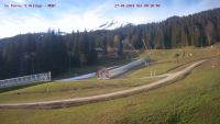
Currently plus 8°C in the centre of La Tania at noon on Monday 26 November 2012 and the snow level is still way up at around 2000/2200m on North facing slopes, perhaps 2800m on South facing. La Tania is North facing by the way, more important than altitude in many ways (the piste maps are “upside down” with South at the top!) and with the trees, snow cannons and excellent grooming and snow management by the pisteurs it has an excellent reputation for resort level top to bottom skiing from the start to the end of the season ).
The situation is about normal for the time of year, Val Thorens is already open (see our video report of the official opening day on Saturday) with surprisingly good skiing and even some nice soft off piste between runs although plenty of rocks only partially hidden and definitely not recommended quite yet. With the main Peclet and Grand Fond Funitels plus the Moraine, Cascades, 2 Lacs and Portette chairs plus some beginner travelators and drags open there was plenty to ski – so much more than this time last year – and more will open soon no doubt with plenty of grooming already completed high up.
So looking quite green down below VT (around 2300m) but this is all about to change with a weather front developing over the Alps this week and temperature plummeting by the end of the week.

Monday above…

and by the end of the week…
Meteo France reporting a snow level down to 400m by Thursday but there will be plenty of rain around lower down for the start of the week with the snow level coming further and further down the mountain. Expect the snow cannons to kick off in earnest this week too as Winter temperatures really arrive.

These consolidated models from the UK, Germany, European, USA etc meteorological offices show the temperature dropping (middle set of models with the red line the 30 year average) and the precipitation along the bottom. When the lines are close together the different models are agreeing and much more chance of them being right – which just goes to show that you can’t really predict the weather more than 4 days out…

Weather map pics courtesy of:
Meteo France
Niederschlagsradar
Wetterzentrale


come on you snooooooooooooooow!
Have faith Sally !