


Three Valleys Piste Maps Winter 2026
Some maps can be quite large, be patient!
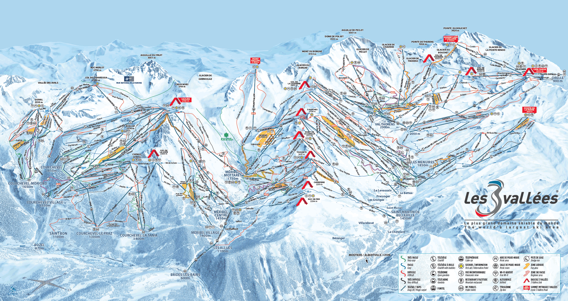
3 Valleys Piste Maps 2026
3 Valleys Piste Map 2026 PDF | 3 Valleys Piste Map 2026 JPG
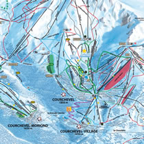
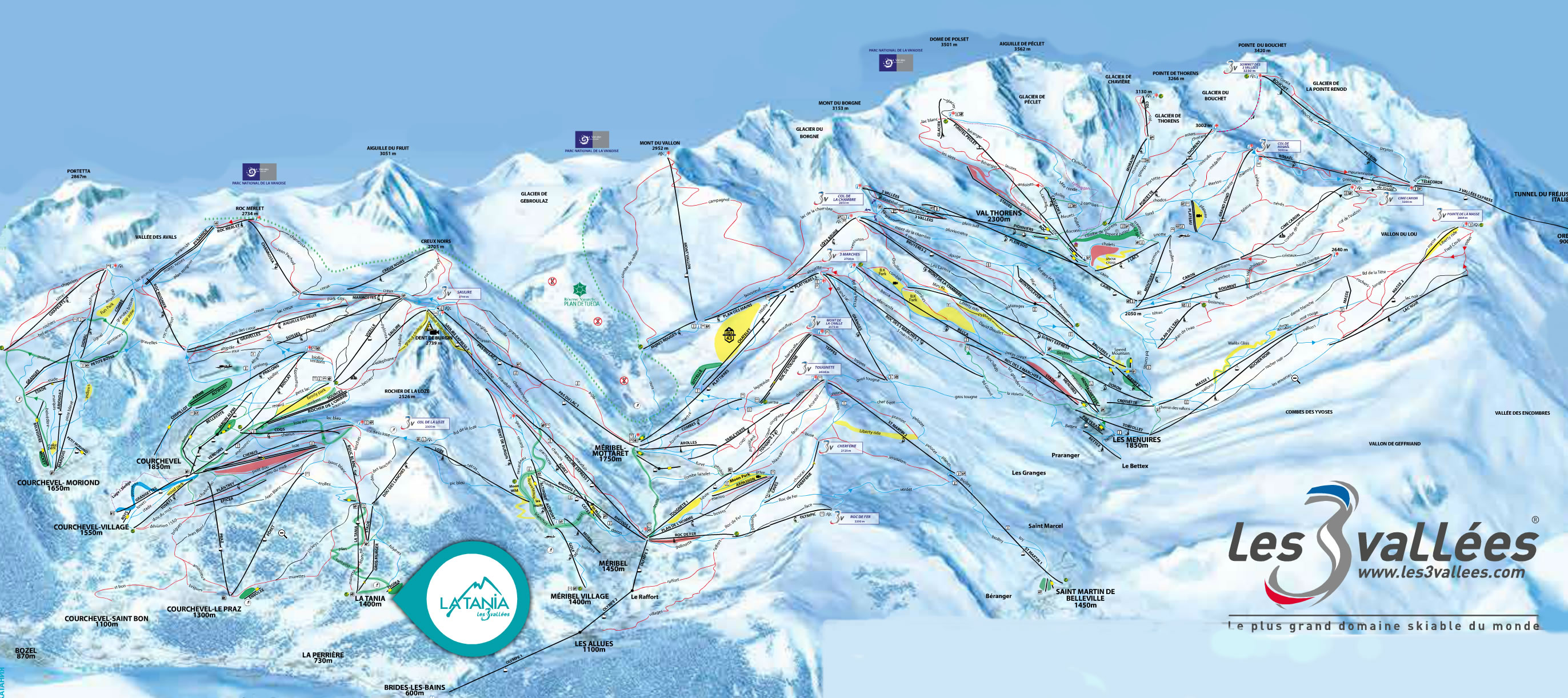
Courchevel / La Tania 2026 PDF | Courchevel / La Tania 2026 JPG
Méribel / Mottaret 2026 PDF | Méribel / Mottaret 2026 JPG
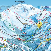
Menuires / St Martin 2026 PDF | Menuires / St Martin 2026 JPG
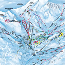
Val Thorens 2026 PDF | Val Thorens 2026 JPG
Orelle 2026 PDF | Orelle 2026 JPG
The Courchevel 2026 Map with What's New
The Méribel 2026 Map with What's New
Courchevel / Méribel Cross Country Skiing Map
3 Valleys Piste Maps 2025
3 Valleys Piste Map 2025 PDF | 3 Valleys Piste Map 2025 JPG
Courchevel / La Tania 2025 PDF | Courchevel / La Tania 2025 JPG
Méribel / Mottaret 2025 PDF | Méribel / Mottaret 2025 JPG
Menuires / St Martin 2025 PDF | Menuires / St Martin 2025 JPG
Val Thorens 2025 PDF | Val Thorens 2025 JPG
Orelle 2025 PDF | Orelle 2025 JPG
Full analysis of What's New on the Ski Area and changes to the 2025 Maps
3 Valleys Piste Maps 2024
3 Valleys Piste Map 2024 PDF | 3 Valleys Piste Map 2024 JPG
Courchevel / La Tania 2024 PDF | Courchevel / La Tania 2024 JPG
Méribel / Mottaret 2024 PDF | Méribel / Mottaret 2024 JPG
Menuires / St Martin 2024 PDF | Menuires / St Martin 2024 JPG
Val Thorens 2024 PDF | Val Thorens 2024 JPG
Orelle 2024 PDF | Orelle 2024 JPG
3 Valleys Piste Maps 2023
3 Valleys Piste Map 2023 PDF | 3 Valleys Piste Map 2023 JPG
Courchevel / La Tania 2023 PDF | Courchevel / La Tania 2023 JPG
Méribel / Mottaret 2023 PDF | Méribel / Mottaret 2023 JPG
Menuires / St Martin 2023 PDF | Menuires / St Martin 2023 JPG
Val Thorens 2023 PDF | Val Thorens 2023 JPG
Orelle 2023 PDF | Orelle 2023 JPG
3 Valleys Piste Maps 2021
3 Valleys Piste Map 2021 PDF | 3 Valleys Piste Map 2021 JPG
Courchevel / La Tania 2021 PDF | Courchevel / La Tania 2021 JPG
Méribel / Mottaret 2021 PDF | Méribel / Mottaret 2021 JPG
Menuires / St Martin 2021 PDF | Menuires / St Martin 2021 JPG
Val Thorens / Orelle 2021 PDF | Val Thorens / Orelle 2021 JPG
3 Valleys 2020 v 2021 Animated GIF
The New 2021 3 Valleys Piste Maps Analysed
2021 Courchevel Valley Hiking & Walking Map
Méribel Footpath Map
3 Valleys Piste Maps 2020
3 Valleys Piste Map 2020 PDF | 3 Valleys Piste Map 2020 JPG
Courchevel / La Tania 2020 PDF | Courchevel / La Tania 2020 JPG
Méribel / Mottaret 2020 PDF | Méribel / Mottaret 2020 JPG
Menuires / St Martin 2020 PDF | Menuires / St Martin 2020 JPG
Orelle Piste Map 2020 PDF | Orelle Piste Map 2020 JPG
Val Thorens Piste Map 2020 PDF | Val Thorens Piste Map 2020 JPG
3V 2019 v 2020 Animated GIF showing all the differences - more in the What's New for 2020
Courchevel 2019 v 2020 GIF
3 Valleys Piste Maps 2019
3 Valleys Piste Map 2019 PDF | 3 Valleys Piste Map 2019 JPG
Courchevel / La Tania 2019 PDF | Courchevel / La Tania 2019 JPG
Méribel / Mottaret 2019 PDF | Méribel / Mottaret 2019 JPG
Menuires / St Martin 2019 PDF | Menuires / St Martin 2019 JPG
Orelle Piste Map 2019 PDF | Orelle Piste Map 2019 JPG
Val Thorens Piste Map 2019 PDF | Val Thorens Piste Map 2019 JPG
2018 v 2019 Animated GIF showing all the differences - more in the What's New for 2019
2018 Piste Maps
3 Valleys 2018 PDF | 3 Valleys 2018 JPG
Courchevel / La Tania 2018 PDF | Courchevel / La Tania 2018 JPG
Méribel / Mottaret 2018 PDF | Méribel / Mottaret 2018 JPG
Menuires /St Martin 2018 PDF | Menuires/St Martin 2018 JPG
Val Thorens / Orelle 2018 PDF | Val Thorens / Orelle 2018 JPG
2018 Cross Country Skiing Map
2018 La Tania Pedestrian Map
2018 Hiking Suggestions
La Tania Official Brochure Winter 2018

On-Line View of 2018 Brochure
2017 Piste Maps
3 Valleys 2017 PDF | 3 Valleys 2017 JPG
Courchevel 2017 PDF
Méribel 2017 PDF
Les Menuires / St Martin 2017 PDF
Val Thorens / Orelle 2017 PDF
3 Valleys Piste Map - 2016 v 2017 Animation of Differences 1933x936
3V Animation x640 | 3V Animation x1024
2016 Piste Maps
3 Valleys 2016 PDF
Courchevel 2016 PDF
Méribel 2016 PDF
Les Menuires / St Martin 2016 PDF
Val Thorens / Orelle 2016 PDF
Courchevel Piste Map - 2015 v 2016 Animation of Differences
3 Valleys Piste Map - 2015 v 2016 Animation of Differences
2015 Piste Maps
3 Valleys 2015 | 3 Valleys 2015 (pdf)
Courchevel Valley / La Tania 2015 | Courchevel Valley / La Tania 2015 (pdf)
Méribel Valley 2015 | Méribel Valley 2015 (pdf)
St Martin / Les Menuires 2015 | St Martin / Les Menuires 2015 (pdf)
Val Thorens / Orelle 2015 | Val Thorens / Orelle 2015 (pdf)
Pedestrian 3 Valleys 2015 | Pedestrian 3 Valleys 2015 (pdf)
3 Valleys Piste Map - 2014 v 2015 Animation of Differences
2014 Piste Maps
Three Valleys 2014 pdf
Courchevel Valley / La Tania 2014 pdf
Méribel Valley 2014 pdf
Courchevel Valley / La Tania 2014 jpg
Orelle 2014 jpg
The 3 Valleys 2014 jpg
2013 Maps (all pdf)
Courchevel Valley / La Tania 2013
Méribel Valley 2013
Les Menuires / St Martin 2013
Val Thorens 2013
The 3 Valleys 2013
Disabled Skiers - Piste / Lift Access and Information

Older Maps in JPG format
The Three Valleys or Smaller Three Valleys
Large Three Valleys Map or Three Valleys PDF format
Courchevel Valley Summer Mountain Bike (VTT) Trails
And even older...
St Martin / Les Menuires / Val Thorens 1990
For resort maps, interactive aerial photos, chalet locations etc Click Here


