


The La Tania Ski Blog
Latest news, snow, pics, gossip and information from the locals in La Tania – latania.co.uk
All the latest news from around the 3 Valleys from the La Tania locals. A real blog since 2006, not just endless re-posts for search engine optimisaton! Photos, gossip, snow reports, what's on and all the latest on the Apres Ski scene... Now fully optimised for iPhone, Touch and Android Mobiles - just go to latania.co.uk/blog and view on your phone. Our other past blogs & favourites here
Weather Outlook Update For La Tania 02 Dec 2014
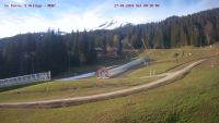
Lots of concern over lack of snow cover low down with 11 days to go before La Tania opens for Winter 2015. The readily available webcams, wide ranges of forecasts and constant social media commentaries all add to this rather than help really.
It has looked a lot worse that this in the past – 4 years ago absolutely no snow on Saulire and then it came big time only days before Courchevel opening. At least Saulire still looks very skiable down to the mid-station but only a track of old snow cannon patches lie below that.

After the Courchevel free preview day on 22 November (and a fantastic opening day in Val Thorens – more here) warm weather has prevented snow cannons from running low down and the preparation of pistes that can take place whether there’s real snow about or not.
Forecasts remain rather all over the place as to predicted snow over the next few days and Courchevel have announced that they are putting back they’re opening from Sat 6 Dec to “The Beginning of Next Week” – this probably due to the fact that just about all forecasts are agreeing that cold weather will return from Friday so snow cannons can be in full effect from then.
Rest assured that the pisteurs of Courchevel are as good as anywhere in the world when it comes to piste preparation and managing limited snow resources using the most modern equipment available.

Each line on the above graph is a separate forecasting model – the top lines being temperature (the red line being the 30 year average) and the bottom lines precipitation. So definitely looking cooler from Friday with the outlook staying cold.
A weather system coming down from the North will hopefully bring a decent amount of snow from Monday – but all a bit too far out for definite predictions yet. See the forecasted movement below

Definitely looking a lot more positive than the end of last week however – so fingers crossed…


Fingers and toes well and truly crossed for good snowfall very soon as we are arriving on the 14th December!!!!