


The La Tania Ski Blog
Latest news, snow, pics, gossip and information from the locals in La Tania – latania.co.uk
All the latest news from around the Three Valleys from the La Tania locals. A real blog since 2006, not just endless re-posts for search engine optimisaton! Photos, gossip, snow reports, what's on and all the latest on the Apres Ski scene... Now fully optimised for iPhone, Touch and Android Mobiles - just go to latania.co.uk/blog and view on your phone. Our other past blogs & favourites here
Snow update – most things open & snowing again

A beautiful morning and fantastic skiing with more pistes opened up including classics like Jean Blanc, Jerusalem and the full Dou des Lanches plus Murettes in La Tania.

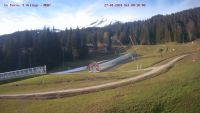
Weather came in again about 2ish with cloud and flat light – now at 5pm it’s snowing once again in La Tania! Great stuff.
Snow is coming in, sun to clouds in 5 minutes

Fantastic piste skiing this morning in warm sunshine – all about to change!
Snow has started now at 2pm however – a bit sooner than originally forecast. Could be a while until we see the sun again….
#stormchasers

Update another hour later – bloody sun came back out… But the snow is on its way, honest…

NICKSKI SNOW REPORT 27TH JAN 2015


About 10cm of fresh snow in resort over night and considerably more higher up although much might have been deposited by the wind eg in the Grand Couloir where we had fresh tracks, see photos. 90% of the pistes in the Three Valleys are now open and assuming we get the predicted snow from Thursday onwards close to 100% of the system should be open. The clouds opened up this morning and we had a couple of quite sunny hours skiing the powder and groomed pistes with powder on top. Nick www.nickskithreevalleys.co.uk 00 33 (0) 673 43 67 69
Lodge du Village & La Terrasse La Brasserie

Just up the road from La Tana in Meribel Village, Lodge du Village has been a regular haunt since opening in December 2001. Possibly the sunniest balcony in The 3 Valleys, great Apres Ski with the legendary Tuesday Bring Your Sisters gigs and a great run down from the Meribel Altiport too – and now a fast chair back up too.
For Winter 2016 the bar (and restaurant underneath now named La Terrasse La Brasserie du Village) is under new ownership but with familiar management as Jez from Jack’s Bar in Meribel is now running the show. The lively apres ski continues with Bring Your Sisters Tuesdays still something special, plenty of live music across the week and all the live sport on TV.
Although sadly there are no pizzas anymore the hot sandwiches are really good with the special chilli hot dog and the ribs both recommended. Food is served in the bar from noon until 21:30 every day too. Pints of Peroni are €7,60.

Meanwhile downstairs (and the large sunny terrace) for fine dining, is now La Terrasse – serving some great dishes with lovely little twists.

Japanese style tuna, seared fillet with a soy, ginger & sesame glaze
The Ribs (€21) are massive and come highly recommended – look out for the special rib night events – and the Tuna (€26) picture above was very good. On the last visit our group enjoyed the La Terrasse Burgers (€18) and The Superfood Burgers (€19) – the latter being a vegetarian dish much to one of our crowd’s surprise (he can read too!) but it was enjoyed all the same being quite a mix of flavours with beetroot, tzatziki, dukkah and melted goats cheese.

So things change, but some things remain the same – rest assured it’s still worth the ski down from the Altiport on the Lapin piste…

![]()
.
Snow Forecast – Still looking good for Thursday…
The “Big Storm” we’ve been tracking for the last few days is still on course to deliver significant snow falls from Thursday.

The storm already massive on the GFS models a week ago – automated systems reporting ridiculous amounts of snow at first. Now downgraded somewhat but still a large amount of snow expected.
There will be high winds and disruption to skiing infrastructure and transport as this weather comes through. The huge low pressure system stretching across from Greenland to Norway will pull cold air directly from the Arctic and push Atlantic systems across France in to the Alps. The UK should see quite a bit of snow too and potentially snow will continue on and off throughout the weekend.
Latest GFS below:

Further snow showers Monday and Tuesday are possible but nothing significant as the Northern Alps seem to be “stealing” this snow, however it remains very cold. Sunday night temperatures falling to minus 8 degrees centigrade at resort level, probably as cold as it has been all season so far. While great skiing is still available first thing on groomed pistes higher up, some runs are starting to become very hard packed and scraped especially later in the day – the cold temperatures preserving the current snow pretty well really and the small top ups helping – hopefully all will be transformed by next weekend.
Actual runs and lifts open / closed hasn’t really changed much this last week – Pisteurs concentrating on what is open so far and all eyes on the end of this week (although with high winds it will take a while to open up parts of the mountain with avalanche safety concerns being dealt with first). That wind will be very cold too – wrap up well everyone…

Radar forecast showing the snow coming in on Wednesday night
Snow Update and Snow Outlook
The fragmented weather fronts continue to break up as they approach this part of The Alps – forecasts remain all over the place for precipitation but at least temperatures are remaining consistently low. This isn’t a case of a high pressure system dominating the area keeping clear weather locked in as is often the case in January and there has been snowfalls frustratingly nearby.
The majority of lifts and pistes are open now of course and masses of good skiing is available across the 3 Valleys but hard and scraped patches are bound to occur especially late in the day on exposed and high traffic areas. Still good cover on Folyeres down to La Tania resort level but the red run has closed and the classic 3 Js of Jockeys, Jean Blanc and Jerusalem remain closed along with the sunny runs of Pic Bleu, Altipole/Mur, Rosiere and obviously runs to the lower villages of Les Allues, Raffort and St Bon. Grand Couloir is also still to open this season.
Of course the qualified and experience guides do know the pockets of off piste skiing with stable snow and enough depth to be safe – certainly worth hiring their skills at the moment both for the safety and enjoyment angle.

Snow showers persist in many forecasts with the weather radar predictions of cloud revolving around parts of the Alps through to the end of the weekend – Saturday could be a good clear day though.
On the very positive side the front above is staying consistent so a good chance at the moment of snow Monday/Tuesday next week if it comes true. Following that could be very unsettled with the possibility of a big storm rolling in across from the Atlantic, but all a bit too far out to call at the moment.
That terrace getting cleared again – a good sign of SNOW

Bouc Blanc terrace beng cleared again in preperation of snowfall tonight. GFS Models looking consistent for a fair amount of snow but some forecasts not as confident with only snow showers predicted.
Currently clear skies at 5pm but clouds building in the distance, trust us Powder Rules will apply tomorrow once again…..
For Example
@weathertoski:
Further light snow has reached the NW foothills of the Alps this afternoon but don’t expect much in the more internal valleys…
Fantastic weekend of snow – more coming Monday night!
So after up to 30cm of fresh snow on Friday night and Saturday followed by clear skies on Sunday we had the best day of the season so far….
Lots of snowy pictures below but the most important thing is there is more snow coming in Monday evening and through the day on Tuesday with temperatures staying cold all week.
The Atlantic Jet Stream is locking in the cold air this week with milder fronts coming across hitting the colder air bringing in snow. After Monday night snow it’s looking like another significant snowfall around Thursday night. Certainly the most Wintery week of the season so far!


La Tania Video Snow Report Saturday 17 January 2015
Tim Wall up on the slopes above La Tania with the family on Saturday morning. Over 25cm of fresh snow a bit more high up and still snowing with more to come next week.
Good chance of some sun tomorrow though, so could be the best day of the season so far!
Outlook for snow this weekend and next week
While images of inaccurate snow forecasts from Global and US forecasting sites are common place – this is from Meteo France this morning!

Interesting that they (along with a few others) have downgraded their snow forecast for tonight but Global Forecasting System models are still looking very good for a decent amount of snow. Much depends on the accuracy of precipitation radar forecasts but think I’ll side with the GFS for now and significant snowfall.
Estimating exact cm depths is still really guess work as too many factors & variances from altitude, pressure, temp, wind, snowfall rate / length, flake size, air/water content etc. But after some rain low down at first surely there’ll be at least a foot of fresh high up on Saturday morning, maybe more and La Tania will wake up to a proper Winter Wonderland – good luck transfer driver heroes…
Note that all weather models are agreeing that it will be colder that average for all of next week – wrap up well!


